Skip to content
The History of Waterford Virginia
A National Historic Landmark
  • Home
    • About Waterford
    • Browse this site
    • Visiting Loudoun County
    • Visiting Waterford
  • Maps
    • Maps
    • Waterford area historical sites and dates
    • Map Showing Construction Dates for Waterford’s Buildings
    • 1853 Map
    • 1875 Map drawn for Charles Janney
    • 1875 Map of the village
  • Timelines
    • Waterford timeline
    • African-American timeline
    • Development timeline
  • African American
    • African-American Experience & Timeline
    • Faith
    • Segregation
    • Slavery and freedom
    • Slavery and freedom — John Devine’s recollections
    • Work
    • second-street-school
      • Student comments
  • Agriculture
    • Farmers
      • Catoctin Farmers Club
    • Barn building – 1923
    • Phillips Farm
    • Mills
      • Old mill
  • Development
    • Development timeline
    • Commercial development
    • Loudoun Mutual Insurance Company
    • Furniture manufacturing
    • Shopping in 1870
    • Tannery
    • Washing Clothes in waterford in the 1800s
  • Early Years
    • Land grants
    • Pioneers settlers
    • Quakers shape the town
    • Waterford in 1760
    • Early 1800s
    • Waterford is a Quaker settlement
    • Log cabins
  • Civil War
    • 1861
    • 1862
    • Battle at Waterford – 1862
    • 1863
    • 1864
    • Epilogue 1865
    • Three women journalists
    • Waterford News
    • Williams Williams hostage
  • After the War
    • Automobiles
      • Automobile stories
    • Cemeteries
    • Cultural influences
    • Churches
    • Jail
    • Ice houses
    • Town government in the 1800s
    • Town ordinances in 1875
    • The village in 1926
    • The village in the 1930s
    • Toasts on July 4th, 1832
    • Waterford Foundation History
  • Search
Print Friendly, PDF & EmailPrint

Maps

Waterford related maps:

  • Map with dates Waterford's buildings were constructed
  • Waterford street maps - Current, Historical, 1875, 1854
  • Area Map with Historical Dates and Places
  • Waterford Historic District Map
  • Aerial View
  • Loudoun County Road Map
  • Northwestern Loudoun County Road Map

Map showing Waterford VA history by Scheel

Historical Map of Waterford by Eugene Scheel

A map showing the dates Waterford Virginia's 107 houses and buildings were constructed

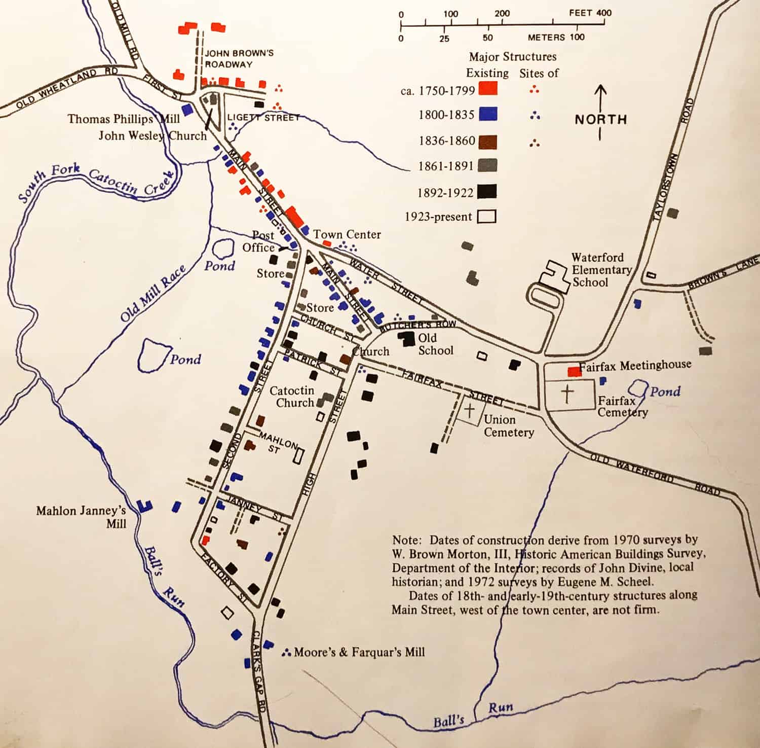
Fifty-nine of Waterford's 107 buildings were constructed before 1861

Historical Map of Waterford by Eugene Scheel

Historical Map of Waterford by Eugene Scheel

Waterford Virginia 18th, 19th, and 20th Century History.   Contact Us

Scroll To Top